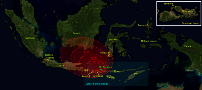
File:1815 tambora explosion.png
Appearance

Size of this preview: 800 × 358 pixels. Other resolutions: 320 × 143 pixels | 640 × 286 pixels | 1,200 × 537 pixels.
Original file (1,200 × 537 pixels, file size: 720 KB, MIME type: image/png)
File history
Click on a date/time to view the file as it appeared at that time.
| Date/Time | Thumbnail | Dimensions | User | Comment | |
|---|---|---|---|---|---|
| current | 13:14, 11 October 2006 |  | 1,200 × 537 (720 KB) | Indon~commonswiki | {{Information |Description= The 1815 Mount Tambora eruption. The red areas are maps of the thickness of vulcanic ashfall. |Source=The base map was taken from NASA picture Image:Indonesia_BMNG.png and the isopach maps were traced |
| 13:12, 11 October 2006 |  | 1,200 × 537 (720 KB) | Indon~commonswiki | ||
| 12:50, 11 October 2006 |  | 1,200 × 537 (686 KB) | Indon~commonswiki | {{Information |Description= The 1815 Mount Tambora eruption. The red areas are w:isopach maps of the density of fallen vulcanic ashes. |Source=The base map was taken from NASA picture Image:Indonesia_BMNG.png and the isopach |
File usage
The following 3 pages use this file:
Global file usage
The following other wikis use this file:
- Usage on ar.wikipedia.org
- Usage on ast.wikipedia.org
- Usage on be-tarask.wikipedia.org
- Usage on ca.wikipedia.org
- Usage on de.wikipedia.org
- Usage on es.wikipedia.org
- Usage on gor.wikipedia.org
- Usage on id.wikipedia.org
- Usage on lt.wikipedia.org
- Usage on ms.wikipedia.org
- Usage on ro.wikipedia.org
- Usage on sh.wikipedia.org
- Usage on sv.wikipedia.org
- Usage on th.wikipedia.org
- Usage on tr.wikipedia.org

